Dikome Balue council is located in Dikome Balue Subdivision, Ndian Division of the South West Region of Cameroon. It is limited in the West by Mundemba council, in the South by Ekondo titi Council, in the East by Konye council, in the North by Toko council. Its GPS points are: X = 04.90148; Y = 009.25526; Z = 1168. It situated at 107 km from Douala and 36 km from Kumba. It covers 5000 km2, that is 1,33% of the national territory. It is made of 14 villages divided oming 3 Zones, including Dikome Balue, Difenda Balue, Mbombe Balue, Mofako Balue (Rata Zone). Ndonono Balue, Ebobe Balue, Betenge Balue, Mekoma Balue, Itende Balue (Membi Zone). Bonji Balue, Bona Balue, Weme Balue Diboki Balue, Bosunga Balue (Bowedi Zone).It has 1 urbanb space (Dikome Balue) with 7 quarters.
The climate is mostly cloudy and rainy, observed temperatures varybetween 18 to 240C.The humidity is about 90%, Rainfall ranges from 2000 to 3000 mm. Two seasons are also observed within the municipality. The longest one being the rainy season; from mid March to mid Novemberwhile the dry season goes from mid November to mid March. But rain falls in Dikome Balue throughout the year. The biggest rainy period being from July to September.
The total soil area is estimated at 500 km2. It is a volcanic fertile soil, rich of humus on the top soil covering the 14 villages. The subsoil is brown while the topsoil is black. It is mixed with stones of micro, medium and big sizes. It is at time made of Clay, sandy and silt. Rampant deforestation and shifting cultivation exposes it soil to fast erosion in some villages. Soils are also degraded by the overuse for unsustainable agriculture practices. No clear soil conservative policy has been put in place. Other threats to the soil are rampant forest fires.
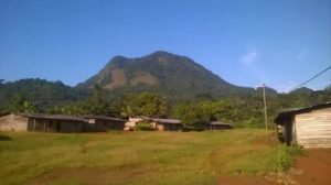
It is diversified. It is shared in between chains of hills and depressions covering the 14 villages. The tallest hills are found at Dikome and Mofako being Rumpi highlands and RATA Mountain with composite volcano of the Cambrian type that has not erupted in our recent times. These mountains range connect with the Manenguba, kupe, Fako and Equatorial Guinea highlands. Beside them, are also very tall rocks at Itende, Bonji and Difenda.
Hydrography network is composed of surface and underground water. Surface water is made of abundant springs found everywhere in each of the 14 villages. They take their source from the hills, flow down to lower area and meet to form 49 streams which also merge to form 9 rivers in the municipality and 5 streams respectively called Mokorikori, Mofombi, Nya, Bosame, and Bifake are found at Dikome, Meme river found at Ebobe, Betenge and Mekoma, Yoke river found at Diboki and Weme, IYAKO river found at Bosunga (hammock bridge); Kombone river found at Mbombe. 16 waterfalls are also found. Underground water is found everywhere with a depth of not less than 1, 5 m.
It is constituted of Rumpi forest reserve, sacred forests and virgin forests. Rumpi forest reserve covers part of Bonji, Mekoma, Diboki and the greater part found at Bosunga. This reserve has a rich biodiversity with different economics trees like Sapelli, mahogany, iroko, Dabema, Doussie, paduck, frake, None timber products such as canes, bush onion, Njansang, bush mango, herbs and a variety of wildlife species such as elephants, gorillas, baboons, varities of monkeys, pukipines, bush pigs, and also a variety of birds. Sacred forest: the only one is found at Mofako.Tree species found in are Camwood, Sappelli, small leave, Iroko and medicinal plants. It covers about 1ha and has a high cultural value and human activities within that area are highly restricted. Virgin forest: The only exiting one is found in Difenda which links Dikome, Tokoand Mbombe and also share boundary in the East by Bakumba and Weme super. This forest is very rich in economic trees such as Azobe, Iroko, Moabi, Mahogany, Doussie, Sappelli, Black afara, Small leave, Bubinga, and Ebony there are also a good number of N.T.F.P. such as bush mango, bush onion, Njansang canes and herbs.
Available mines are: Black stones (basalt), Gneiss, Sand, Clay, Muscovite and Quartz. Abundant Black Stones (basalt) and Gneiss are found in the rivers, streams and throughout the villages of Dikome Balue, Ndonono, Ebode, Mofako, Betenge, Mekoma, Itende, Bona, Bonji, Diboko, Bosunga, Difenda, and Mbombe. Abundant Sand is found in the rivers at Weme, Bosunga, Difenda and Mobmbe. Clay is found at Dikome and Bonji and precious stones. Abundant quantity of Muscovite, Quartz and sand are found at Bosunga. These minerals are still under exploited. Only black stones are exploited with traditional techniques and tools (fires, hammers, rubber) by local population on the demand ofbuilding construction contractors executing government projects within the municipality.

Dikome Balue council is located in Dikome Balue Subdivision, Ndian Division of the South West Region of Cameroon. It is limited in the West by Mundemba council, in the South by Ekondo titi Council, in the East by Konye council, in the North by Toko council. Its GPS points are: X = 04.90148; Y = 009.25526; Z = 1168. It situated at 107 km from Douala and 36 km from Kumba. It covers 5000 km2, that is 1,33% of the national territory. It is made of 14 villages; 1 urban space (Dikome Balue) with 7 quarters, 3 development zones: Rata,Bowedi and Nembi (refer to CDR)
The climate is mostly cloudy and rainy, observed temperatures varybetween 18 to 240C.The humidity is about 90%, Rainfall ranges from 2000 to 3000 mm. Two seasons are also observed within the municipality. The longest one being the rainy season; from mid March to mid Novemberwhile the dry season goes from mid November to mid March. But rain falls in Dikome Balue throughout the year. The biggest rainy period being from July to September.